Systematic Landscapes
Henry Art Gallery
Seattle, Washington
“Maya Lin has an extraordinary ability to convey complex and poetic ideas using simple forms and natural materials.”
Richard Andrews
Director Henry Art Gallery

Photo: arcspace
The exhibition is on view through September 3, 2006.
Maya Lin works with a vocabulary of form culled from her study of landscape. By altering scale and materials, she creates works that connect the ideal and the real.
The three installations all engage with the problem of bringing land masses into architecture by translating landscapes, two real and one imagined, into the materials of architecture while inviting viewers to move under, on, or through the works.
Each work is composed of a single material. Each, configured to evoke a different aspect of landscape, went through the same process of design: creation of a three-dimensional model in Lin’s studio, translation via scanning or plotting into digital drawings, and finally, full scale construction in Seattle.
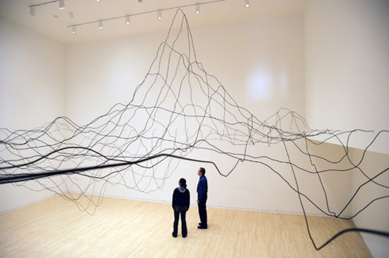
2x4 Landscape is composed of more than fifty thousand vertical two-by-four boards placed in a configuration minutely detailed in models and drawings. Covering approximately twenty-four hundred square feet, it rises from a plane of short two-by-four segments to a hill ten feet tall. From some views the sculpture reads as a land from, and from others as a rising wave.

Photo: arcspace

Photo: arcspace
Water Line is a line drawing in space of a particular underwater location on the Mid Atlantic Ridge. The site rises a few miles from the sea floor and is visible on the surface as Bouvet Island, one of the most remote islands in the world. Working with scientists at Woods Hole Oceanographic Institute, Lin and members of her studio, developed a topographic rendering of the seascape. The rendering was translated into architectural scale and fabricated from quarter-inch diameter aluminum tubes.

Photo: arcspace

Photo: arcspace
Blue Lake Pass, takes its name from a landmark within a selected zone. The cubes forming the sculpture are made from vertical sheets of particle board with the top edges cut to match a topographic line. Pulled apart into a grid, the topographic image is disjointed and the spaces between the cubes become narrow paths, or cuts, through the geography of the sculpture, exposing strata much like a highway carved through a mountain pass.

Photo: arcspace
The unseen landscape is further explored in the Bodies of Water series, Lin’s portraits of specific inland island seas, whose expanses of salt water are partially or wholly landlocked.
Here Lin takes up the representation of these immense volumes of water and shapes them from plywood layers. The resulting sculpture is balanced on its deepest point. The three bodies of water represented in the exhibition, the Caspian, Black, and Red Seas, are the most endangered in the world.

Photo: arcspace
Black Sea 2006 (Baltic birch plywood)

Photo: arcspace
Red Sea 2006 (Baltic birch plywood)

Photo: arcspace
Caspian Sea 2006 (Baltic birch plywood)
Pin River is a linear view of a river system, composed of tens of thousands of straight pins pushed into the wall to create a flow of silver that is a shadow image of the Columbia River. A subtle environmental message is underscored by the slightly exaggerated swelling of the pins at the multiple dam sites on the river.

Photo: arcspace

Photo: arcspace
Also featured are plaster reliefs of imagined landscapes that are embedded directly into the walls, large drawings of land forms and river sheds, and photographs and video of Lin’s recent large scale earthworks.
Models and plans for the Confluence Project, Lin’s biggest undertaking to date, are also included in the exhibition.

Photo: arcspace
Cape Disappointment State Park Model (2004 - 2006)
Viewing Platform to Fish Cleaning Platform
An ambitious collaboration between the artist on the one hand and various Pacific Northwest communities on the other, the Confluence Project will create permanent environmental art installations at seven sites, strung along a 450-mile stretch of the Columbia River and its tributaries. These site-specific works will mark the route of contact between Native Americans and the Lewis and Clark Expedition, providing opportunities to reflect upon the past, think about the future, and experience the connection between human history and the natural world.
The ceremonial completion of Cape Disappointment State Park, the first of seven sites, took place on April 22, 2006.
Cape Disappointment arcspace feature

Photo courtesy Maya Lin Studio and Gagosian Gallery


No comments:
Post a Comment
Reply to message